

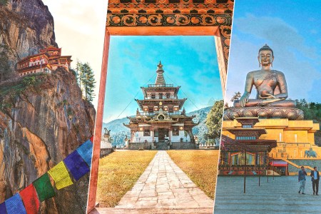
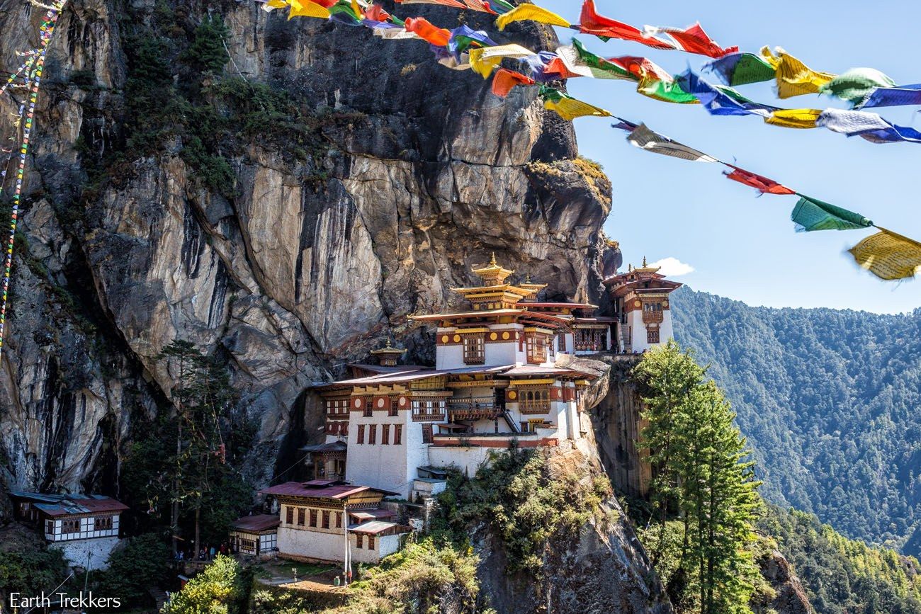
Bhutan, a South Asian country tucked in the Himalayan Mountains, has become a bucket list destination for many, and not just because it’s known as the “Land of Happiness” (the country claims a high score on its self-invented Gross National Happiness Index). Many travelers come to see the country’s most well-known postcard image: Tiger’s Nest, the quintessential, secluded Buddhist monastery and temple complex, built on a rocky cliffside in piecemeal between the 9th and 17th centuries.
However, because of its lofty and high-altitude cliffside position at 10,240 feet (3,121 m), you can’t just roll up to the iconic structure in a car or tour bus like it’s Barcelona’s Basilica de la Sagrada Familia. You must hike on an upward trail for two to five hours at elevation (depending on your fitness level) — meaning you should already be acclimated before arriving at the trailhead. This is the reason why Tiger’s Nest is often saved for the end of a tour of Bhutan; it’s not just to save the best for last, but to give tourists time to adjust to the country’s elevation for at least a few days — especially if you’re traveling from sea level. As it stands, simply landing at Bhutan’s main airport in Paro already thrusts visitors up to an elevation of about 7,200 feet.
For me, an avid cyclist, I discovered one of the best ways to acclimate to Bhutan’s higher elevations is to gradually ride —and be immersed in — its lower valleys, which boast some of the most awe-inspiring natural scenery in the country, with farms, rice terraces, Buddhist temples, and prayer flags waving in the winds.
I learned this on a bespoke cycling tour I did with local tour operator Guides of Bhutan, which not only sets up cultural and active excursions led by local Bhutanese guides, as well as homestays in local communities, but is also one of the biggest advocates for the country’s emerging cycling culture. They set me up with a sweet, dual-suspension Kona Process mountain bike, in addition to a support truck team to drive me in between stages, plus an enthusiastic guide named Tshering Wangchuk, a.k.a. “Sixless,” one of the country’s most experienced competitive mountain bikers.
Stage One: Paro to the District of Thimphu
Starting in the town of Paro is inevitable; it’s where all the international flights land at the country’s only international airport. From there, there’s only one main road towards the capital district of Thimphu — naturally called the Paro, or Thimphu Highway — and along the way, about 9.3 miles in, is the 15th century Tachog Lhakhang monastery, where I suggested we start a warm-up ride. It was an easy acclimatization route along the side of the road — only 4.8 miles — that was generally flat, low on traffic, and below the initial 7,200-foot elevation, with no big inclines.
Riding with my front shocks tightened stiff for the pavement, I was also acclimating to the sights of Bhutan to come: river valleys, the occasional cow on the side of the road and prayer flags propped on poles, waving in the wind to spiritually disperse its inked prayers of good fortune across the land. At the confluence of the Bachu and the Wang Chu Rivers, forming the Chuzhom River, we crossed the Chuzom Bridge — you’ll know it when you see a billboard of the beloved king and queen prominently on display. From there it wasn’t long before we crossed into the district of Thimphu, home of the eponymous capital city, where we ended our warm-up ride just before an uphill and increasing city traffic. We loaded the bikes back onto the truck near a family-run roadside stand, which was selling items I’d come to be familiar with over the next week: farm-fresh vegetables, dried red chilies and smoked yak cheese, a Bhutanese farmer staple that can keep your jaw chewing for hours.

Stage Two: Dochula Pass to Punakha
After seeing a couple of sights in Bhutan’s capital Thimphu — the Buddha Dordenma statue and the Royal Takin Preserve— we started the next leg at one more historical and cultural site just outside the city center: the Druk Wangyal Chortens, a memorial comprised of 108 stupas honoring the lost souls from the 2003 skirmish between the Bhutanese Army and Indian Assam insurgents. The collection of stupas stand high at Dochula Pass, at about 10,170 feet, and it was there that we unloaded the bikes for a 32-mile ride to the next main town of Punakha. Starting a ride at over 10,000 feet sounds rough — my heavier breathing attested to that — but the subjection to that altitude didn’t last long, as most of the ride was a consistent downhill. In fact, the route has an elevation loss of about 6,000 feet.
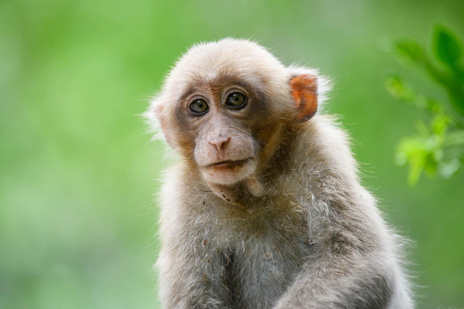
Along the way, prayer flags were strung up from above in a few places, and at ground level, we passed through one area frequented by monkeys: Assamese macaques. We offered a few of our potassium-boosting bananas, which they grabbed from us with their hands like little people, before going on their way. I couldn’t help but smile at the exchange, and I began to see how this was indeed the Land of Happiness.

A Jaunt in Bhutan, Where Happiness Is King and Travel Is Exclusive
A recent trip to the idyllic South Asian country shows how things have changed (but mostly stayed the same) with new post-pandemic tourism rulesStage Three: Rides Around Punakha
Punakha is one of Bhutan’s major traveler hubs. As the former capital, it’s culturally rich with many historic sites, including the Punakha Dzong, the second oldest Buddhist fortress in the country. Many travelers base themselves here for a few days to see various sites — as did I — but I did manage to get a couple of acclimatization rides in with Sixless, at elevations ranging from about 4,000 to 9,000 feet. One ride had an elevation gain of 1,722 feet, going up the paved switchbacks from the valley to the lofty Nobgang Monastery. From there, we put the bikes in full suspension mode and went down via one of the mountain-bike trails — the Madman Talo Nobgang Trail — which is actually an ancient hillside footpath that’s beeen repurposed for bikes.
Another ride was a more leisurely 7.5-mile morning bike route mostly along the east bank of the Pho Chhu River. However, the most exhilarating part of the leg was riding our bikes across the river on Bhutan’s longest suspension bridge (525 feet), spanning the length of about one-and-a-half American football fields.

Stage Four: Punakha to Khotokha Valley
In our most grueling cycling stage yet, we rode east from the former capital for only about 18.6 miles, but with an elevation gain of 2,205 feet. Starting on the outskirts of central Punakha, we biked on the main road, passing through the district of Wangdue Phodrang, before really getting off the beaten path. In fact, we took a hard right turn onto a new road that, at the time, wasn’t even logged on Google Maps yet. While that road was new and freshly paved, it was not so forgiving on my calf muscles; it gradually ascended uphill via winding switchbacks to Tashila Pass, at 9,098 feet. Our saving grace, at least for a couple of turns, was the company and encouragement of curious, giddy children who had just been released from school for the day.
What goes up must come down, and after making it beyond the pass, adorned with the colors of hanging prayer flags, we were rewarded with a fun and fast downhill to the Khotokha Valley, our home for the night in a unique homestay that Guides of Bhutan had arranged: an active Buddhist monastery.
Stage Five: Gangtey Valley and Phobjikha Valley Loop
After a truck ride from the monks’ home in Khotokha to Pelela Pass, followed by a scenic hike along the Longtey-Lomay Trail up and over Jigche La Pass, we found ourselves in Gangtey Valley, home to a few hotels, which cater to the tourists who dare venture beyond Punakha. Basing ourselves in Gangtey for a couple of nights — one at a homestay, another at a hotel — Sixless and I spent one of the days riding a 20.6-mile loop around the Gangtey Valley and adjacent Phobjikha Valley, roughly at 9,840 feet above sea level.
Unlike other Bhutanese valleys, these two aren’t lush with green rice terraces. In these parts, it’s potatoes that are the staple starch crop, making the landscape mostly a dusty brown. In fact, cycling through felt more like riding in the Old American West with all the ranches and cattle, save for the occasional sights of Buddhist stupas, temples, prayer flags and black-necked cranes — revered migratory birds, in for the season before heading back to Tibet. Icebreakers with potato farmers and livestock herders always began with the respectful greeting “Kuzuzangpo!” which almost always resulted in reciprocated smiles — adding points to the country’s Gross National Happiness Index.

Stage Six: Back in Paro Valley
Phobjikha Valley was the farthest east we traveled, and so, after about a week of acclimatization rides, I had more than enough red blood cells to backtrack west — via the support truck — to Paro, where it all began. Paro is actually home to the famed Tiger’s Nest monastery and temple, and therefore is the country’s main tourism hub where I spent my remaining days in Bhutan. Still, before hiking up to Tiger’s Nest, I did one last ride in and around Paro, this time not only with Sixless, but with Guides of Bhutan founding partner (and avid cyclist) Ugyen Dorji, who brought along his cycling cousin, Jigme Tenzin. We were eventually joined by two teens from the local Dragon Riders MTB Club — Bhutan is also known as “Land of the Thunder Dragon” for its loud seasonal thunderstorms — and together, we affectionately formed the “Kona Gang” with our mountain bikes from Kona Bikes Bhutan.
I was practically a local by this point, and our pedal-powered bike gang joined the other Sunday morning cyclists of the community, who were riding a common route on the main road about 6.5 miles uphill, gaining about 1,000 feet of vertical, before gunning it back down. The turnaround point was the 17th-century fortified temple Drukgyel Dzong, which has been undergoing reconstruction and renovation since a fire destroyed it in the 1950s.
Ultimately we ended up back in central Paro to cross the Jangsa suspension bridge and ride a 9.6-mile loop around the valley suburb of Dopshari, roughly at 7,200 feet. I greeted passing farmers with smiles and “kuzuzangpo,” while Sixless and the boys flexed their bike skills with wheelies, bunny hops and creative jumps off of side hits.
While I was not ready for such stunts, I was 100% ready to take on the Tiger’s Nest trail on foot, both physically and mentally, having connected — and shared smiles — with Bhutanese locals. My concentration of hemoglobin improved over the past week…and so did my own happiness index.
More Like This
Whether you’re looking to get into shape, or just get out of a funk, The Charge has got you covered. Sign up for our new wellness newsletter today.